By Johnny Coomansingh
Donald W. Meinig’s article titled, ‘Ten Versions of the Same Scene’ will be employed in some aspects of this script. Meinig looked at different views of a landscape including landscape as nature, habitat, artifact, system, problem, wealth, ideology, history, place, and aesthetic. In view of this, I am apt to remind people of the line in a Christmas song, “Do you see what I see?” Some people will not see what I have seen. Anais Nin was wise to state: “We do not see things as they are. We see things as we are.”
To keep a 9:00 am appointment with an officer at the National Insurance Board located in the Borough of Arima. I waited for about ten minutes for a taxi at the corner of the Eastern Main Road (EMR) and Kangalee Street, Valencia. At that hour, it was as though the Sun, combined with a high humidity, ushered in a sweaty scenario just standing there. Seeing that taxis were not appearing, I decided to walk to the Valencia junction to flag a taxi adjacent to the Valencia Police Station. After walking for five minutes up came a maxi-taxi.
Without any choice, I boarded the crappy, almost derelict re-banded, maxi-taxi. Despite the poor ambience inside the vehicle I was still glad that I got this taxi because I was already sweating. I said to myself that the journey would not be long and still bearable. It seemed that the Sun came out in all its blazing glory with a hot and steamy vengeance upon me.
The padding on the seat was severely flattened; worn, rendering the little folding seat quite hard and uncomfortable. I said a pleasant “good morning” to the passengers who were on board. Some answered, others couldn’t care. It could be that they were wrapped up in their own problems for that day. It was an atmosphere like “what’s so good about the morning anyway.”
That morning, for whatever the reason, I woke up at 4:00 am. It could be that my mind was in overdrive because of my rambling and restless thoughts about the state, the horrible condition in which Trinidad and Tobago has found itself; the place was definitely a landscape of problem. It is quite possible that I worry too much about this country where I was born. I got off the bed, walked around a little, drank some water and went back to bed at about 5:00 am. I ambled out of bed at 6:00 am, thanked the Almighty for the faith He had in me that I could live another day.
Munching on a few oat-bran Crix crackers, a sliver of New Zealand cheddar cheese and a half cup of Nestle Taster’s Choice coffee, I was now ready to face the 20-30-minute journey. I quickly brushed my teeth, showered and left. Added to the fact that air-conditioning was non-existent in the vehicle, I was utterly uneasy in the seat I occupied on this seven-dollar trip. The ride in this vehicle was kind of similar to a bus I rode in Jamaica.
Back then, I was reading for a post-graduate diploma in Mass Communication, at the Caribbean Institute of Mass Communication (CARIMAC), University of The West Indies (UWI), Mona, Jamaica. Not really knowing the culture of Jamaica, I ventured to leave the comfort of my apartment one evening to ‘explore’ the nearest town to where I lived. I went to the town of Liguanea. I had a meal and waited for the bus to Papine, a town adjacent to Mona Commons, where I resided.
It was unbelievable, but a bus stopped for me; a bus that looked fully loaded and jam-packed like sardines in a tin. All I heard was “Go down! Move back! Nuff room, nuff room!” There wasn’t really any more room! I didn’t see any more room. We all smelled each other. It was, for the want of a better word, a Jamaica jam! People’s backsides were protruding out of the windows of the bus. Moreover, the bus leaned to one side so precariously that I swore it would have toppled. Nevertheless, I arrived safely in the town of Papine and I waved the bus goodbye. Bon voyage! Sorry about the digression, but some memories keep me alive.
Along the way on the slow maxi-taxi drive to Arima I passed a bridge that is still undergoing repairs. The authorities claimed that the bridge was repaired but one lane was still closed. Sometimes I get the feeling that such landscapes of problem and a certain kind of political ideology would forever haunt us. Following were several businesses: a tyre shop, an auto parts shop, a doctor’s office, a rum shop, a National Lottery Play Whe booth, a grocery, and the newly constructed roundabout in Valencia. This landscape of place bore the toponym ‘Almond Tree Corner.’ For as long as I knew, an almond tree graced this corner as a landmark for travelers. The tree is gone and in its place is a caricature of a lighthouse standing in the middle of the roundabout. Compared to yesteryear, the little town between Sangre Grande and Arima is now quite built up.
It’s true that the Valencia Old Road merges unto the Toco Road that takes you to the Toco Beach and the Toco Lighthouse about 20 miles away. I still question the reasons for placing this fake lighthouse at this location. The building looks odd; kind of placeless or lacking a sense of place. It is as though no thought was put into the completion of the roundabout. To add to Meinig’s theory, I saw this ‘lighthouse’ as part of a landscape of ambiguity. Others may see an aesthetic landscape. Around the edge of the circumference of the roundabout were small billboards with pictures illustrative of the wildlife and interesting places in Valencia.
Around the roundabout is the Valencia Police Station and several business places including a Chinese grocery, a bakery, a pharmacy, meat shops, a National Petroleum gas station, hardware stores, bars (rum shops), food stalls, and makeshift vegetable stalls. Quite visible, and very present was a landscape of history, and a landscape of artifact combined. Traveling westward beyond the checkpoint pillars of Fort Read that the United States Army left behind on both sides of the road, I saw more rum shops, tyre, and auto repair shops, an ATM booth, several little vegetable stalls, a seller of honey, a mosque, Doubles vendors, coconut water vendors, fishmongers with large signs advertising the types of fish they sold. We also passed the Vlencia River where I was baptized in 1965.
After passing the Aripo Road junction on the right, coming into view, were two buildings, one for undocumented immigration detainees, and what was once the Aripo Livestock Station. On the left were the connector roads to the Churchill-Roosevelt Highway (CRH). The CRH was built by the Americans to facilitate the efforts of the Second World War (WWII), a definite landscape of place, history, and ideology.
The Aripo Road takes the traveller to the Aripo Village, way up into the rainforest of the Northern Range, landscapes of nature, system, and habitat. El Cerro del Aripo at 940 meters (3084 ft), is the highest point in Trinidad. The Aripo Livestock Station which was once operated by the Ministry of Agriculture Lands and Fisheries is now a home for several heads of buffalo; a landscape of wealth. Corn fields were present in the pasture possibly growing as a supplement for the animals. The Livestock Station was probably a big ‘experiment’ undertaken by the Trinidad government to raise cattle for the ‘dairy industry.’ It was hoped that Trinidad and Tobago would become self-sufficient in milk. It’s still a dream.
Many opponents of the experiment, political and otherwise, intimated that the project would be a failure. The planting and growing of Pangola grass (Digitaria eriantha) seemed not to work. In turn, the project received its fair share of criticisms and jokes, one of which was, ‘Cows eating mud and giving milk.’ Here’s is where I saw a landscape of ideology, and certainly a landscape as problem…serious and costly political problems.
Next on the trip was the Guanapo River bridge, a landmark once known as ‘Double Bridge.’ This river brought back thoughts of fluvial geomorphology, river bottom soils and floodplains that I studied in the disciplines of agriculture and geography. Here was a landscape of system, the movement of water in the transport and deposition of soil. Food production became uppermost in my mind at this point on the journey. There were breadfruit tree stands, coconut palms, pewah (Bactris gasipaes) trees (a peach palm called chontadoro in some South American countries), avocado trees, mango trees, and bananas trees.
Also dotting the sector were broiler chicken and egg production farms. This area was seen as a landscape of wealth. Beyond that point was the Guanapo Road that led to the municipal dumpsite. At the intersection of the road and the EMR, were all kinds of items, old buckets, paint cans, old chairs, discarded doors, wood, and other paraphernalia; whatever was saleable. These items were retrieved from the dump, which could also be considered as a landscape of wealth, at least for the less fortunate. Then I came to the village of Maturita.

Onwards from the village of Maturita that begun from the second US checkpoint pillars illustrative of Trinidad’s involvement with the Second World War (WWII) were ramshackle roadside food and vegetable stalls, auto mechanic shops, agro shops, green grocery stalls, more Doubles vendors and rum shops. Prominently present on the verges of the EMR, was an appliance repair stop. Piled on top of one another were washing machines and other paraphernalia; can’t miss it. The traffic here was, as we say, “stiff.” Traffic slows from the town of Maturita right into Pinto Road junction where things got really slow at that hour when all commuters were trying to get to school and work. This was, unquestionably, another landscape of problem.
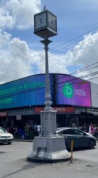
I took my stop at the maxi-taxi stand situated obliquely opposite to the Massy Stores Supermarket and walked past the Republic Bank and up to the most famous landmark in Arima, the Arima Dial; a landscape of place, history and aesthetic. According to the National Trust, the Dial purchased from Nice, France, was installed in 1898 by John Francis Wallen, the mayor.
However, for such a rich country, I couldn’t explain the level of homelessness I saw along the way. I saw at least four homeless people on the sidewalk. Two were still sleeping on cardboard ‘beds’ while two, with sleepy eyes, were just sitting there, begging. Again, I would have to add to Meinig’s theory. This to me was a landscape of poverty and sadness. Just then, I remembered my ten-year-old son’s calypso titled: ‘I’m sorry for the vagrants,’ in which he pointed out his concern for the less fortunate people in our society:
“When I think for a moment;
Each one in torment;
See them sleeping on the cold, hard pavement.
I’m sorry for the vagrants in the Borough of Arima;
“I’m sorry for the vagrants, even in Santa Flora.”


